SNSAT
National Space Program
Through the exploitation of space as a means and a resource in favor of national development, the National Space System seeks to position the country as a Pole of Services and Scientific-Technological Development, making it a relevant actor for the region in the reduction of the digital and technological divide.
Access to space that allows the development of technologies, generation of knowledge, promotion of talent and provision of space services that directly benefit the increase in the quality of life and security of people, through the development of defense strategies and the public policy decision making.
The National Space Program is an end-to-end solution for the development of space capabilities, providing various applications for both civil and defense purposes, and comprises a wide range of Satellites, AIT capabilities, state-of-the-art ground infrastructures, and comprehensive technology transfer.
Unique advantages
- Defence
- Border Control
- Intelligence
- Earth Monitoring
- Maritime Vigilance
- Water Administration
- Forestry Monitoring
- Fishing Monitoring
- Urban Development
- Mining
- Disaster Recovery
Chilean Space Program
SNSat is a proven, deployed and successfully implemented program in Chile, bringing great advances in space capabilities along with comprehensive technology transfer.
- 10 Satellites
- Advanced Mission Control
- National Geographic Portal
- Civilian and Defence Applications
- Technology Transfer
SNSat comprises three segments:
- Space
- Ground
- Technology Transfer
Spatial Segment
The National Satellite System (SNSat) is a project that is aimed at observing the Earth, through national micro and nanosatellites, as well as a constellation of international satellites.
In order to contribute to strengthening the National Space System, its capabilities were expanded to the area of communications, launch systems, and positioning and navigation systems.
Currently, SNSat is formally implemented and already receives the images obtained from international satellites.
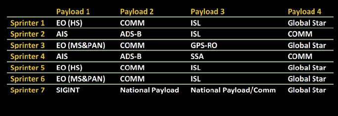
The space segment includes a variety of platforms and payloads, providing a unique combination of space capabilities.
| Tipo de satélite | Nombre del satélite |
|---|---|
|
VHR EO |
Runner |
|
NANO 12U |
Sprinter |
|
Observación Terrestre |
Knight |
Super Resolution Satellites
- Effective and accessible
- Ideal for high-demand constellations
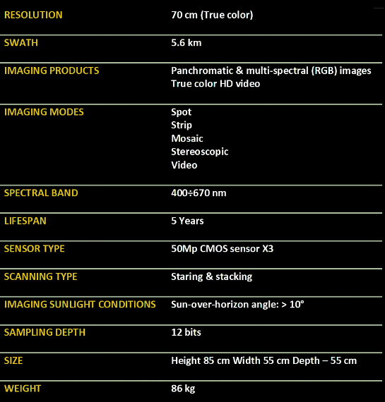
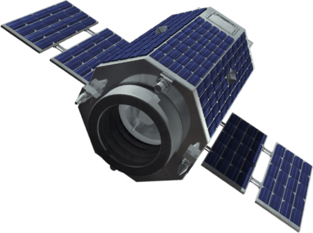
RUNNER
A high-resolution, high-availability satellite, with unprecedented performance and amazing accessibility, Runner is the ideal entry point for establishing space capabilities.
- High resolution true color video
- Effective and accessible
- Secure and encrypted communication
- Adaptive Onboard Processing
- Optimal for satellite constellations
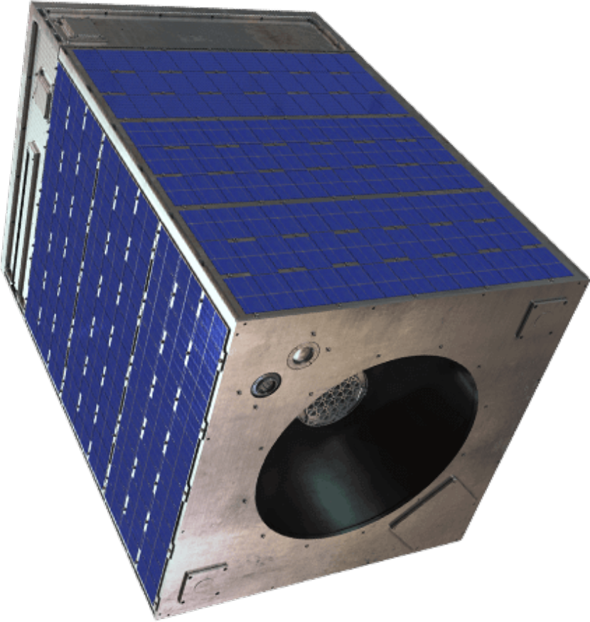
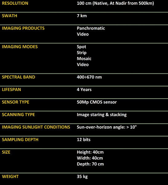
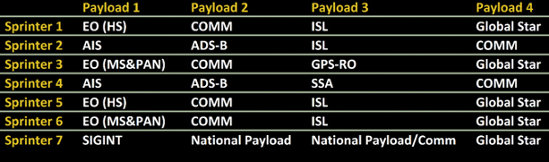
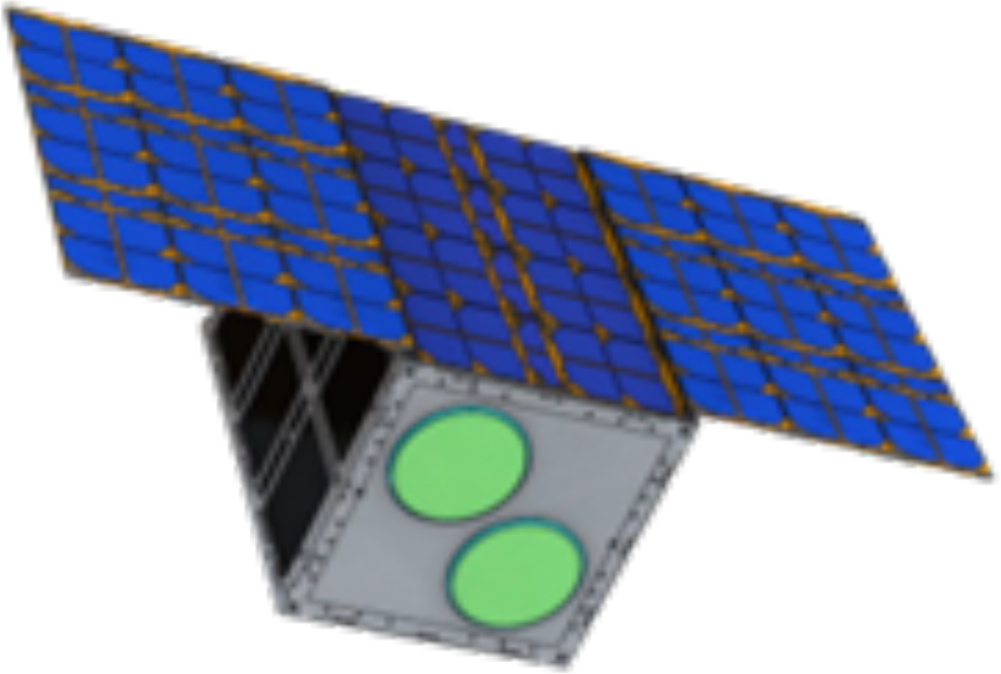
SPRINTER
High-capacity, high-resolution, low-weight microsatellite specifically designed to operate as part of large-scale HIGH REVISIT satellite constellations.
Sprinter offers exceptional high-quality imaging, agile maneuvering, enhanced target collection capability, and wide area coverage, making it a class-leading intelligence gathering asset.
The Sprinter's small size and weight allow for affordable launch options while allowing the use of advanced payloads.
- resolution images < 100 CM
- Optimum Size / Cost Duty Point
- On board processing
- Light, small size, cost-effective
- Ideal para constelaciones de alto rendimiento
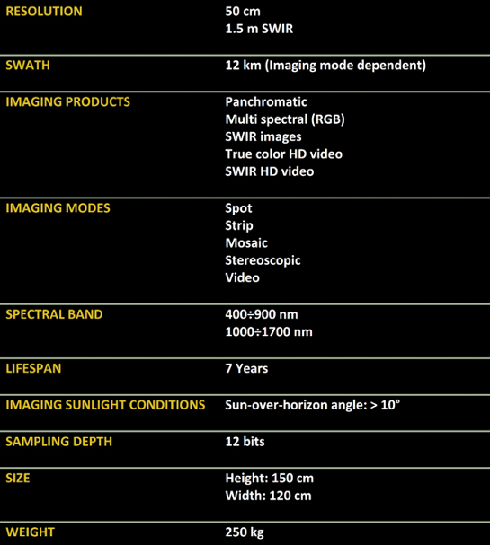
KNIGHT
The world's first new military-grade standard satellite, it provides the performance of a high-end Earth observation satellite at an economical balance of labor.
Quality
- HD SWIR images and video
- 50cm super resolution
- True color
CONDITIONS
- Low light conditions
- Dust & Haze Operation
Security
- Data encryption
- Cyber Protection Suite
- Direct Access Capability
Ground Segment
The Ground Segment is one of the three pillars that make up the National Space System, together with the Space Program and Institutions.
It contemplates the creation of a National Space Center (CEN) located in the Metropolitan Region, which includes in its facilities a Space Technologies Development Laboratory, a BigData Laboratory and the Entrepreneurship and Innovation Laboratory. Likewise, the creation of two Satellite Earth Stations, in the cities of Antofagasta and Punta Arenas.
It provides real-time satellite control capabilities through Satellite Mission Centers and ground stations.
Satellite images and videos are stored in state-of-the-art data centers and are easily accessible through user-friendly applications.
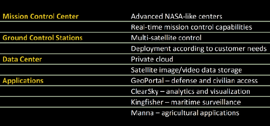
Mission Control Center
Oversees all SNSat aspects, including constellation management, technical control, mission planning and more.

Ground Control Stations
They provide direct link to the satellites, both for uplink (sending commands, mission update) and downlink (receiving telemetry, images and videos).
- Direct tasking and direct reception
- Integration with Data Centers
- Interoperability & Backup
- Multi-Site Operation
Data Centers
The data centers are the hub of the computational power, storage and applications of the SNSat program, forming a private cloud that serves all end users, both civil and defense.
All satellites are linked to data centers.
Architecture based on ESRI COTS software.
GeoPortal and Applications
It enables easy access to high-quality satellite imagery and video for both civil and defense clients, providing the raw data and tools for multiple applications.
- ClearSkyTM - Analysis and visualization
- KingFisherTM – Maritime Surveillance
- IntelTM Irrigation – Agriculture
Clear Sky
Provides multi-layered data analysis and advanced analytics that enable integrated situational awareness, anomalous activity detection, early warning systems, and more.
- Run multiple image processing algorithms at the same time
- Works with deep learning algorithms that detect objects in EO and SAR satellite images
Built-in capabilities including comparative analysis and image enhancement
King Fisher
Multilayer maritime intelligence system, created for in-depth analysis of large maritime areas of interest.
- Follow moving targets
- Provides domain awareness
- Detect illegal activities
- Decision support for operators
Irrigation Intelligence
Farming app that optimizes agronomy, crop management, irrigation and more, based on satellite imagery and AI algorithms.
Irrigation recommendations based on a combination of remote sensing data, timely weather information, and specific crop models.
The model detects the observed evapotranspiration from each pixel in the field, deriving the exact amount of crop water use.
Growers can select from hundreds of growing protocols from the agricultural database.
Technology Transfer
Developing independent space capabilities, with world-class courses and hands-on experience.
Assembly, integration and testing of 7 microsatellites and 28 payloads in an advanced 1,000 m2 facility.
AIT installation
1,000 m2 assembly, integration and test facility, optimally designed to allow hands-on experience in assembling satellites and payloads.
Education
Inseparable from technology transfer, the education component of the SNSat includes school programs and academic training.
This program is located within the National Satellite System and is made up of the School Space Program, the Postgraduate Program and various Technical Programs.
In the school environment, the program has focused on students from 7th grade to 4th grade and is being developed in the regions where the National Space System will have Satellite Earth Stations, that is, in Antofagasta, Punta Arenas and Santiago.
Likewise, it is expected to expand its execution throughout the country. In the undergraduate and postgraduate program, training courses are being developed to generate Diplomas, Masters and Doctorates and an I2D program with the development of CANSat at an institutional and national level.
- Cooperation with local universities
- Teacher training courses
- Unique opportunity to send an experiment to the international space station